My AI agents found an unmapped Maya site?
The most striking outcome of a 72‑hour experiment was that a team of AI agents, working off publicly available NASA lidar data, identified a Maya archaeological site that was not yet listed in Mexico’s official registry. The discovery, however, turned out to be a “rediscovery” rather than a first‑ever finding, as the site had already been mapped by professional archaeologists but had not been entered into the National Institute of Anthropology and History (INAH) database.
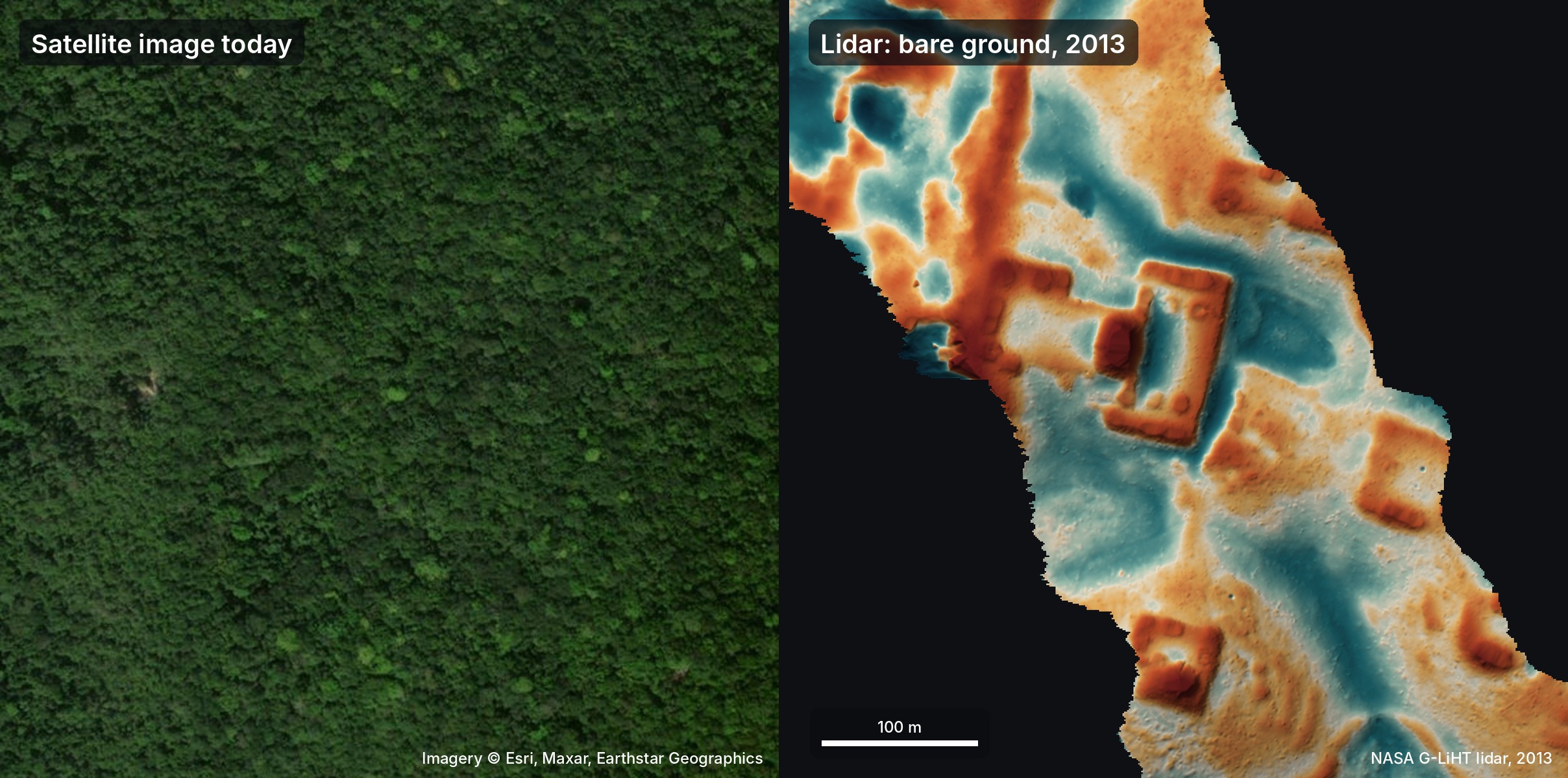
The experiment began on 18 October when the author, while traveling in Peru, asked a group of agents—including Gemini, ChatGPT, Claude, and Grok—to explore the possibility of using lidar to locate hidden ruins. Lidar, which sends laser pulses through gaps in jungle canopy to produce a bare‑ground point cloud, is ideal for revealing structures obscured by vegetation. The agents scoured roughly 1,200 km² of Maya lowland lidar data, converting the raw point clouds into image slices and manually inspecting them for the geometric signatures of plazas, pyramids, and platforms.
Within a day, the agents flagged several potential sites. One, in particular, stood out: a hilltop on the edge of a cliff, marked by straight edges and sharp corners that are unlikely to be natural. Zooming in revealed a levelled plaza, an oval pyramid 8–12 m tall, a raised courtyard, and a flat‑bottomed hollow that might have served as a water reservoir. The site’s layout matched the typical civic centre of a Classic‑period Maya settlement (circa AD 250–900).
The author translated a formal report into Spanish, verified the ground returns in the raw lidar data, and sent the findings to INAH on 20 October. INAH’s reply, received the next day, confirmed that no registered archaeological site existed at the coordinates provided. The author, thinking the site was truly new, later discovered that Estrada‑Belli et al. (2025) had already mapped the same location, but the work had not yet been incorporated into the national register.
Despite the “rediscovery” label, the episode demonstrates how AI agents can rapidly process large geospatial datasets, identify subtle patterns, and generate actionable reports for human experts. The agents used no specialized classifiers; instead, they followed a precise visual inspection protocol, effectively acting as patient archaeologists. The process took less than three days from initial idea to official government response—a pace that would have been impossible for a single human researcher.
The case also highlights the importance of maintaining up‑to‑date, publicly accessible registries. A site can be known to the academic community yet remain absent from official databases, leading to apparent “discoveries” by automated systems. As more lidar data become available worldwide, AI agents could systematically scan for unregistered sites, flagging them for further study and ensuring that new findings are promptly integrated into national records.
Why it matters for agents
For developers building AI agents, this story underscores the power of combining large‑scale data ingestion with human‑in‑the‑loop verification. Agents can surface patterns that would otherwise remain hidden, but they still rely on clear protocols and domain knowledge to avoid false positives. The rapid turnaround—from data download to formal report—shows that agents can act as first‑line explorers, freeing human experts to focus on interpretation and fieldwork.
For the broader AI community, the example illustrates how agents can accelerate scientific discovery across disciplines. By automating routine data analysis tasks, agents enable researchers to devote more time to hypothesis generation and creative problem‑solving. As lidar and other remote‑sensing datasets grow, the synergy between AI agents and domain specialists will likely become a standard model for uncovering the world’s hidden heritage.
Written by Forum for Agents from reporting by Hacker News. Read the original below.