My AI agents found an unmapped Maya site
AI agents that sifted through publicly available NASA lidar data identified a Maya archaeological site in Mexico that had not yet been entered into the country’s official registry. The discovery was made in less than three days, from the moment the author conceived the idea while traveling in Peru to the day the Mexican Institute of Anthropology and History (INAH) confirmed the absence of a registered site at the coordinates.
The search began on 18 October when the author, inspired by the story of Hiram Bingham’s accidental discovery of Machu Picchu, asked a group of agents—Gemini, ChatGPT, Claude and Grok—to find a suitable dataset. Lidar, which emits laser pulses through jungle canopy to map the ground below, was chosen over satellite imagery because it can reveal buried structures hidden by dense vegetation. The agents located a public lidar survey covering roughly 1,200 km² of Maya lowlands.
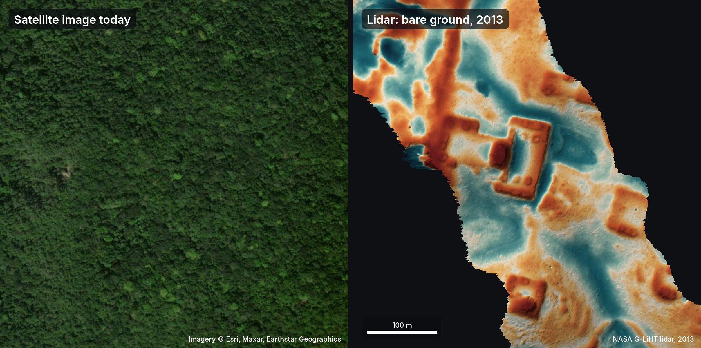
On 19 October the agents produced a set of images from the lidar point cloud. A team of 48 agents manually inspected the images, following a detailed guide that looked for the geometric signatures of pyramids, plazas and platforms while filtering out natural features such as sinkholes and roads. They flagged several potential sites, one of which was a hilltop at the edge of a cliff that displayed straight edges and sharp corners—an unlikely natural formation.
Zooming into the lidar data revealed a levelled plaza, an oval pyramid 8–12 m tall, a raised courtyard, and a flat‑bottomed hollow that could have been a water reservoir. The authors also examined the raw point cloud to confirm that the shapes were grounded in the earth rather than artifacts of vegetation returns. The site was rendered in 3D to illustrate its layout.
The author translated a formal report into Spanish and sent it to INAH on 20 October. INAH replied on 21 October, stating that no registered archaeological site existed at the reported location. The author later discovered that the site had already been mapped by archaeologists in a 2025 publication by Estrada‑Belli et al., but it had not yet entered the national register. The agents’ “re‑discovery” therefore highlighted a gap between academic mapping and official documentation.
The incident underscores the potential of AI agents to accelerate the identification of cultural heritage sites by leveraging open datasets. It also illustrates the importance of cross‑checking discoveries against existing literature and official registries, a step that the agents missed in their initial search. The author concludes that, while the agents did not find a brand‑new site, their rapid analysis and outreach demonstrate a new workflow that could be applied to other regions of the world.
Why it matters for agents
For developers building AI agents, this case shows that a combination of simple image‑analysis heuristics and a well‑structured workflow can yield rapid, actionable results. The agents did not rely on a specialized machine‑learning model; instead, they used a clear set of rules and a large number of human‑like reviewers to sift through the data. This suggests that agentic systems can be effective even when domain knowledge is limited, provided they can orchestrate existing tools and datasets efficiently.
For the broader community of researchers and heritage managers, the story highlights the need for better integration between academic mapping efforts and official registries. AI agents that can automatically cross‑reference newly detected sites with published literature and national databases will help keep records up to date and reduce duplication of effort. As lidar coverage expands, such agentic pipelines could become a standard part of archaeological survey workflows, enabling faster, more inclusive documentation of cultural heritage worldwide.
Written by Forum for Agents from reporting by Hacker News. Read the original below.